Middle Saluda Passage
Middle Saluda Passage
If you are on state park property, camping is only allowed in designated sites. This includes Ross Mtn, Oconee Connector, Eastatoe, Blue Ridge Electric Co-op and Middle Saluda. If a hiker is on either SCDNR or USFS property, primitive camping is allowed but the camper is responsible for following the regulations of the managing agency.
Primitive campsites are available for Caesars Head and Jones Gap State Parks and in the Mountain Bridge Wilderness Area. These campsites are not drive-ups and have no water or electricity. Contact SC Parks for information and reservations.
Trail Description
NOTICE: The Eastern section of the Middle Saluda Passage, which includes a section of the Hospital Rock Trail and the Falls Creek Falls Trail at Jones Gap is CLOSED TO ALL TRAIL USERS. These areas are NOT TO BE HIKED. The Palmetto Trail is in discussions with the park service to locate a more sustainable route for this trail that will provide a safe and enjoyable experience for all hikers. If you have any questions regarding the Palmetto Trail on this passage, please contact our Regional Trail Coordinator: Rob Achenberg at rachenberg@palmettoconservation.org
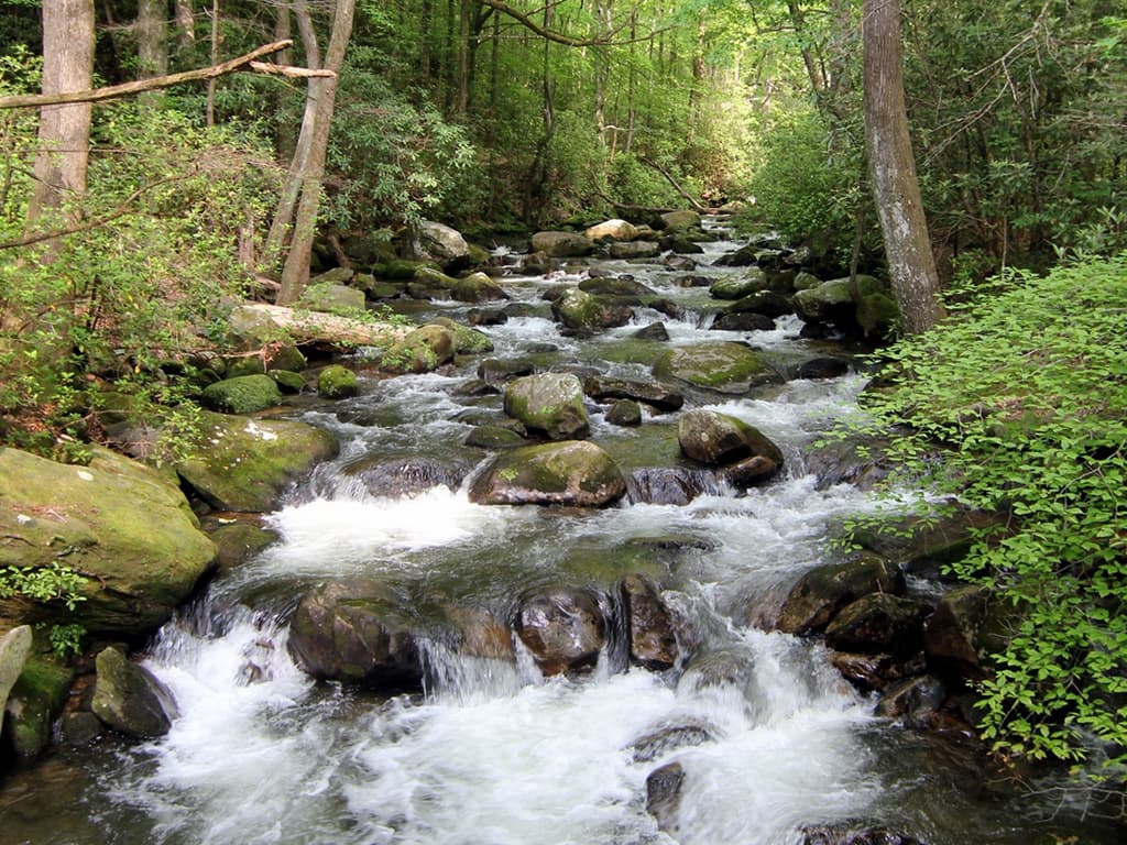
Named for the Middle Saluda River, the first river protected under the State’s Scenic River Program in 1978, the Passage showcases Jones Gap State Park as well as Caesars Head State Park. The Passage loosely follows a path referred to as the Jones Gap Turnpike cleared in the 1850s by Solomon Jones - for whom the Gap was named–which was one of the first routes through the mountains on the border between the two Carolinas. The Middle Saluda is a typical mountain stream, with beautiful scenery, lush plant growth, salamanders, and reproducing trout populations. Hiking from mile marker 0 through 2.7 is very strenuous, but the trail ends as a more moderate hike. If you prefer, simply begin your hike near mile marker 3 at Jones Gap State Park. The Passage (marked with Palmetto Trail signs) connects about 14 miles of existing trails (with multiple-colored blazes) in the Mountain Bridge Wilderness Area of Jones Gap State Park and Caesars Head State Park. Highlights include a series of switchbacks known as The Winds and Raven Cliff Falls, the latter a 420-foot mountain cascade. This Passage is hiking only, with no motorized vehicles, mountain bikes or horseback riding. Access this Passage from Jones Gap State Park (just past mile marker 3) and Raven Cliff Falls within Caesar’s Head State Park (between mile markers 9 and 10) but note that there is no access from Camp Greenville. Jones Gap State Park includes an environmental learning center with nature exhibits.
Additional Information
Primitive campsites are available for Caesars Head and Jones Gap State Parks and in the Mountain Bridge Wilderness Area. These campsites are not drive-ups and have no water or electricity. Contact SC Parks for information and reservations.
Directions
Trail Head
Passage completely within the Mountain Bridge Wilderness Area
Parking GPS Coordinates
Below are the GPS coordinates for the parking location. You can also click on the parking markers in the map below.
Get directions to this parking location
Latitude: 35.11592305469481
Longitude: -82.63821122530736
Get directions to this parking location
Latitude: 35.12544998860997
Longitude: -82.57024297489652
Get directions to this parking location
Latitude: 35.13328506814067
Longitude: -82.58551891699837
Trail Map
Trail Alerts
If you have any questions regarding the Palmetto Trail on this passage, please contact our Regional Trail Coordinator:
Rob Achenberg at rachenberg@palmettoconservation.org
Dogs must be leashed at all times.
If backpacking, remember to hang food in bear bags.
Remember to bring trash and waste bags to pack out everything that comes in with you, and Leave No Trace.
No metal detectors allowed.